♦♦♦♦♦♦♦♦♦♦♦♦♦♦♦♦♦♦♦♦♦♦♦♦♦♦♦♦♦♦♦♦♦♦♦♦♦♦♦
Only two of the docks that were built in the 19th Century are preserved in their entirety today: Greenland Dock and South Dock (sometimes known as Sweden Dock), both at the east side of Rotherhithe peninsula and connected to each other by a small channel. South Dock, today London’s biggest marina, is the only one of the two docks to maintain its operational connection to the Thames.

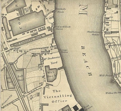
The Greenwood map of 1827, showing the East Country Dock as a long thin finger next to the much wider Greenland Dock
South Dock began life as the East Country Dock, which was built in 1811 by the East Country Dock Company. Its construction followed the establishment of the Baltic Dock Company followed teh sale of land owner Joseph Moore for the purpose of creating a new dock and timber ponds. Moore owned 45 acres of land in the Rotherhithe peninsula. The area chosen for the ponds was sold to the Commercial Dock Company (and became Lady Dock and Lavender and Acorn ponds) whilst an Act of Parliament was passed in 1811 to complete the East Country Dock. The proposal must have been a significant one because, as the 1827 Greenwood map shows, it would have required the destruction of a number of buildings as well as two roads that led from Deptford Lower Road (today just Lower Road) to the river, to be replaced by a new road, which is now Plough Way.
Ralph Dodd was the engineer originally hired to build the East Country Dock in 1801, on a considerable wage of £600 a year. He was a rather mixed blessing, full of ideas but not always the best person to execute them. In 1802 he fell out of favour with the Eastern Dock Company and he was given a gratuity and dismissed as engineer, apparently because he was simultaneously engaged on other work and his fees were too high. Whatever the reason for his dismissal, he was quickly replaced.
The dock first appears on maps in the early 19th Century as East Country Dock, clearly shown on maps on Greenland’s map of 1827, Smiths Map of 1828, Cary’s map of 1837, and Davies’s map of 1843 as a long thin, dock, as long as Greenland Dock was at that time, but around a quarter of its width. It is difficult to imagine why such a long, thin dock was considered to be advantageous. The East Country Dock Company, which was formed in 1807 and was named for its trading connections with the eastern Baltic.
As I described on the Before South Dock page, even before the establishment of the East Country Dock Company, the Commercial Dock Company was in competition with the Grand Surrey Docks and Canal Company, their dock networks running in parallel in Rotherhithe. Into the already complicated scenario of competing dock systems came the East Country Dock Company, which was formed in 1807 and was named for its trading connections with the eastern Baltic. They had acquired the land parallel to the Commercial Dock Company’s Greenland Dock. Quite why the Commercial Dock Company had failed to acquire the land itself is unknown. The newly formed company built a new dock specifically for the Baltic timber trade, and it opened in 1811. Because it was owned by a rival company, the new dock was not linked into Greenland Dock, but had its own lock out onto the Thames. It seems to have been referred to occasionally as Baltic Dock, but that was never its official name.

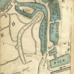
East Country Dock, bottom right in
1828. Immediately to its north is
Greenland Dock. The Grand Surrey Docks and Canal System runs alongside the Commercial Dock system.
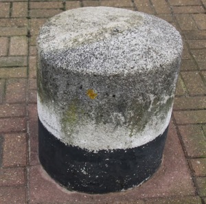
Price wars followed, undermining all three companies. Although attempts were made by the Commercial Dock Company to take over the East Country Dock, the East Country Dock Company retained its ownership of the dock until 1850 when the dock was purchased for £40,000. This was followed in the early 1860s by the decision was to amalgamate the Grand Surrey Canal and Docks Company and the Commercial Dock Company to form one large company, which became the Surrey Commercial Dock Company in 1864. The situation at that time is reflected in the 1868 Ordnance Survey Map, which shows the East Country Dock connected to Greenland Dock and various connections made between ponds and docks between the two formerly separate networks of docks and timber ponds. Most of the docks and ponds were renamed during this period of transition, and the East Country Dock became South Dock. The East Country Dock was not connected to Greenland Dock, which was owned by a rival company, and it therefore required its own lock out onto the Thames. The dock was built specifically for the Baltic timber trade. It is thought that the distinctive granite bollards that dot the edges of the dock probably date to this time.
Although attempts were made to take over the dock, the East Country Dock Company retained its ownership of the dock until 1850 when the dock was purchased for £40,000 by the Commercial Dock Company, which was already developing vast areas of Rotherhithe for mercantile use.
For the next part of the story click here: South Dock 1850 – 1902

